
SIMPCO GIS Helps Improve Access to Food Resources Across Siouxland
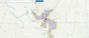
At SIMPCO, collaboration and innovation help communities make informed decisions and improve quality of life. Recently, Regional Planner and GIS Specialist Ryan Brauer partnered with the Siouxland District Health Department to develop an interactive mapping tool designed to help residents locate food resources and transportation options throughout the region.
The new Food Access Map provides an easy-to-use, web-based resource that displays:
- Full-service grocery stores
- Emergency food pantries
- Public transit routes
By bringing these resources together in one location, the map helps residents identify nearby food access points and determine whether public transportation is available to reach them. The tool supports community members who may face transportation barriers while seeking access to healthy and affordable food options.
This project demonstrates how geographic information systems (GIS) technology can be used to address real-world challenges and support public health initiatives. Through partnerships like this, SIMPCO continues to provide technical expertise that strengthens communities and improves access to essential services.
"We are proud to partner with organizations like the Siouxland District Health Department to create practical tools that make information more accessible and help residents connect with important community resources," said Ryan Brauer.
Explore the Food Access Map
🔗 Residents can access the interactive Food Access Map here: Food Access in Siouxland